Subscribe to receive top agriculture news
Be informed daily with these free e-newsletters

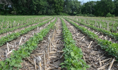
At a Nebraska Educational GIS workshop, educators visit a working farm to learn about soil conservation and precision ag technology.
July 22, 2016
School may be out for the summer, but summer is often when teachers have the opportunity to become students. Seven Nebraska educators did just that when they participated in a June 6-7 workshop, "Educating the Next Generation of Nebraskans About Soil Conservation Using the Power of Geographic Information Systems (GIS)" at Southeast Community College in Milford.

NO-TILL EDUCATION: As part of a Nebraska Educational GIS workshop, seven teachers visited a working farm to view soil conservation practices.
The workshop was sponsored by Nebraska Educational GIS (NeEdGIS), which is a group promoting the use of geospatial technologies to enhance K-12 education in Nebraska. The goal of this workshop was to provide classroom teachers training in how to use GIS technology to create interactive lessons about soil conservation for their students.
As part of the workshop, participants visited a working farm to view soil conservation practices. Sarah Gray, state planning specialist with NRCS, explained how conservation practices help improve crop production while protecting natural resources like soil and water.
"Conservation practices like no-till, terraces and grass strips work together to prevent erosion, keeping soil on the field and out of lakes and streams," Gray said.
The teachers took photos of the practices and recorded GPS coordinates to mark where the conservation practices occurred in the field. The teachers then interviewed Gray about the practices.
The second day of the workshop, the teachers combined their photos, GPS coordinates and information in a GIS application template to create a story map. A story map is an online interactive map that uses photos, text and maps to explain, demonstrate or showcase something — in this case, soil conservation practices.
Creating a story map allowed workshop participants to apply what they learned about soil conservation and how to use the GIS applications.
Brian Baskerville, Nebraska NRCS cartographer, was a guest speaker June 7 and discussed GIS and GPS technology. "Learning how to use GIS and GPS technology can be a great way to engage with students," he said. "Instead of talking about a subject that used to just be shown in a book, these teachers can now work with students to create an interactive learning tool using information found locally. What better way to learn about soil conservation than to use information found at a farmer's field right down the road?"
Source: Nebraska NRCS
You May Also Like
Enter a zip code to see the weather conditions for a different location.


